Lake County Documents
Below we've posted Blackstill East's current Zoning Documents and Conceptual Development Map (dated 2009)
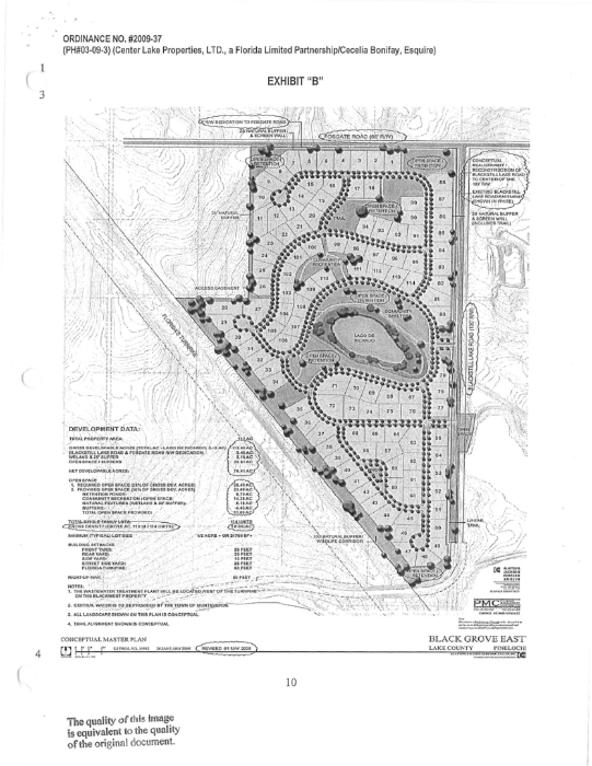
Black East is zoned Planned Unit Development (PUD) by Ordinance 2009-37 and is part of the Rural Transition Future Land Use Category. The Rural Transition allows different densities based on the amount of open space provided.
Blackstill East Development Concept from 2009
This document shows the concept of the sub-division proposed when the land was rezoned from Agricultural to a Planned Unit Development (PUD) in 2009.
- This concept drawing shows 114 lots of a minimum half acre (21760 sq. ft).
- This drawing shows a density of 1.0 du/ac (dwellings per acre).
- The developer had requested to change this to 2.5 du/ac.
Quote from the April 26, 2016 Minutes
“If the property is annexed and the water supplied by Clermont then the town would retain the $250,000. For this to happen the town would have to agree to a density level and price point comparable with other developments along SR50 and Blackstill Lake Road. Blackstill West density is between 2.8 dwelling units per acre (du/ac) and 3.0 du/ac and they are asking for 2.5 du/ac.“
The link to this document is below.
This is the current zoning from the County on this land. The land was rezoned for this development in 2009.
2009-37 Center Lake Properties.pdf
Adobe Acrobat document [4.8 MB]
The Rural Transition allows different densities based on the amount of open space provided.
RuralTransitionCategory.pdf
Adobe Acrobat document [66.0 KB]